A TROPICAL REVOLVING STORMS Is A Generic Term For A Low Pressure System Over Tropical Or Sub-tropical Waters, With Thunderstorm And Winds At Low Levels Circulating.
TROPICAL REVOLVING STORMS Moves Between West And West-north-west In The Northern Hemisphere And Between West And West-south-west In The Southern Hemisphere.
FORMATION
TROPICAL REVOLVING STORMS Are Like Big Engine That Use Warm And Moist Air As Fuel.
That Is Why TROPICAL REVOLVING STORMS Form Only Over Areas Approximately Between 5°n And 30°n Latitude And 5°s And 30°s Latitude, At Temperatures Normally 27°C Or More.
That Cause The Warm And Moist Air Rises From Tropical Oceans Surface.
Because The Warm And Moist Air Moves Up And Away From The Tropical Oceans Surface, Will Create Less Air Left Near The Tropical Oceans Surface, Causing A Low Pressure Area Below.
The Low Pressure Area Will Absorb The Air From Surrounding Areas With Higher Air Pressure Into It.
Now The Absorbed Air Will Becomes Warm And Moist And Rises, Too.
As The Warm And Moist Air Continues To Rise, The Surrounding Air Swirls Into Take Its Place. As The Warmed And Moist Air Rises And Cools Off, The Water In The Air Forms Clouds.
The Entire System Of Clouds And Wind Spins And Grows, Fed Through The Ocean’s Heat And Water Evaporating From The Surface.
As The Storm System Rotates Faster And Faster, An Eye Forms In The Center. It Is Very Calm And Clear In The Eye, With Very Low Air Pressure. Higher Pressure Air From Above Flows Down Into The Eye.
When The Winds In The Rotating Storm Reach Speeds Of 8-13 Knots, But Can Travel As Fast As 34 Knots, Then It Is Called “Tropical Depression”.
When The Winds Reach 34 Knots, Then It Is Called “Tropical Storm”
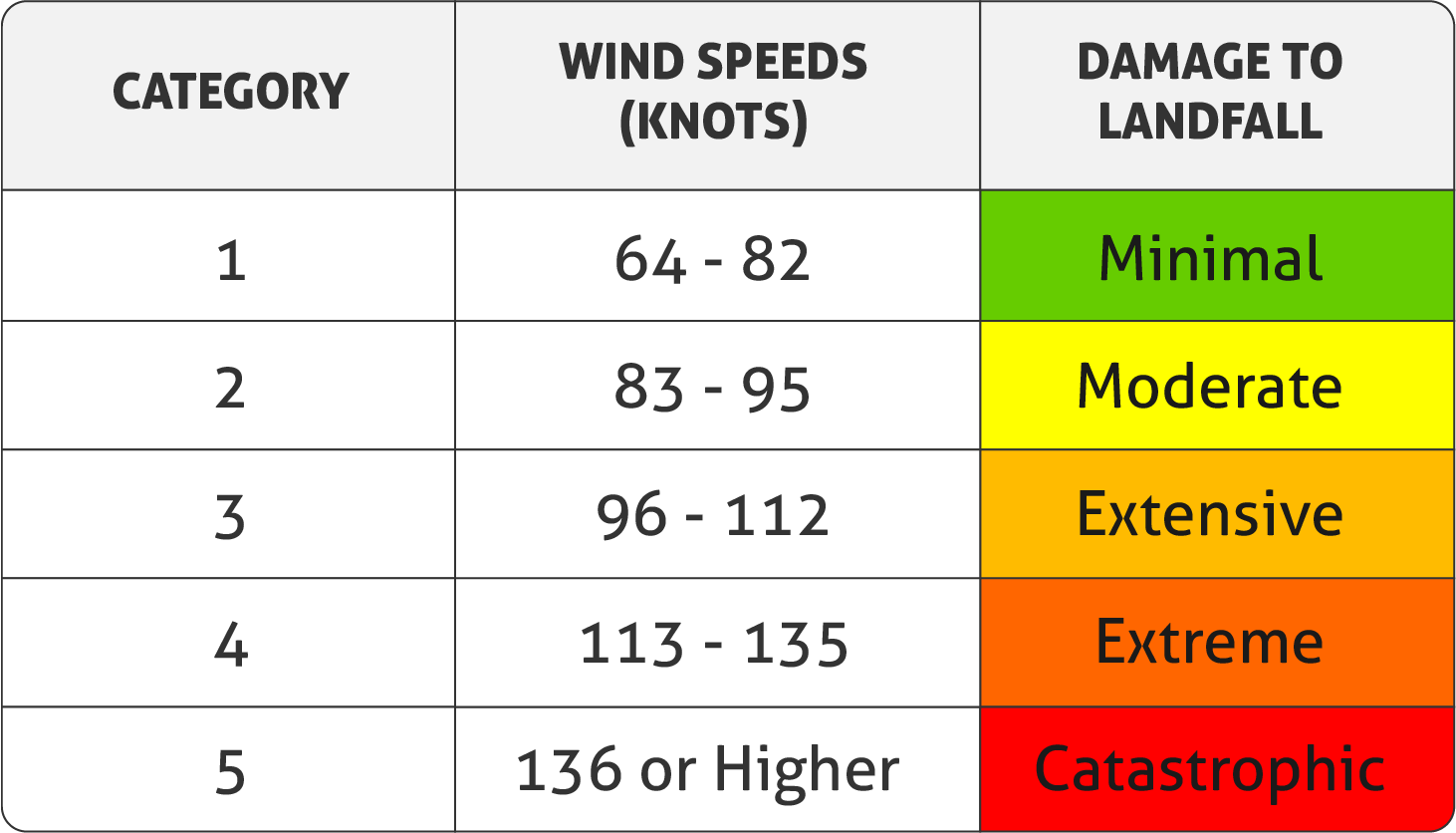
When The Wind Reach 64 Knots Or More, Then The Tropical Storm Is Officially Called By One Of The Below Names:
“Hurricane” Is Used On The Western Side Of North Atlantic And South Pacific.
“Typhoon” Is Used On The Western Side Of North Pacific.
“Cyclones” Is Used In The Bay Of Bengal And The Arabian Sea.
“Cordonazo” Is Used On The Eastern Side Of North Pacific.
“Willy – Willy” Is Used On The Eastern Side Of South Indian Ocean.
DECAY STAGE
Tropical Cyclones Usually Weaken When They Hit Land, Because They Are No Longer Being “Fed” By The Energy From The Warm Ocean Waters. However, They Often Move Far Inland, Dumping Many Inches Of Rain And Causing Lots Of Wind Damage Before They Die Out Completely.
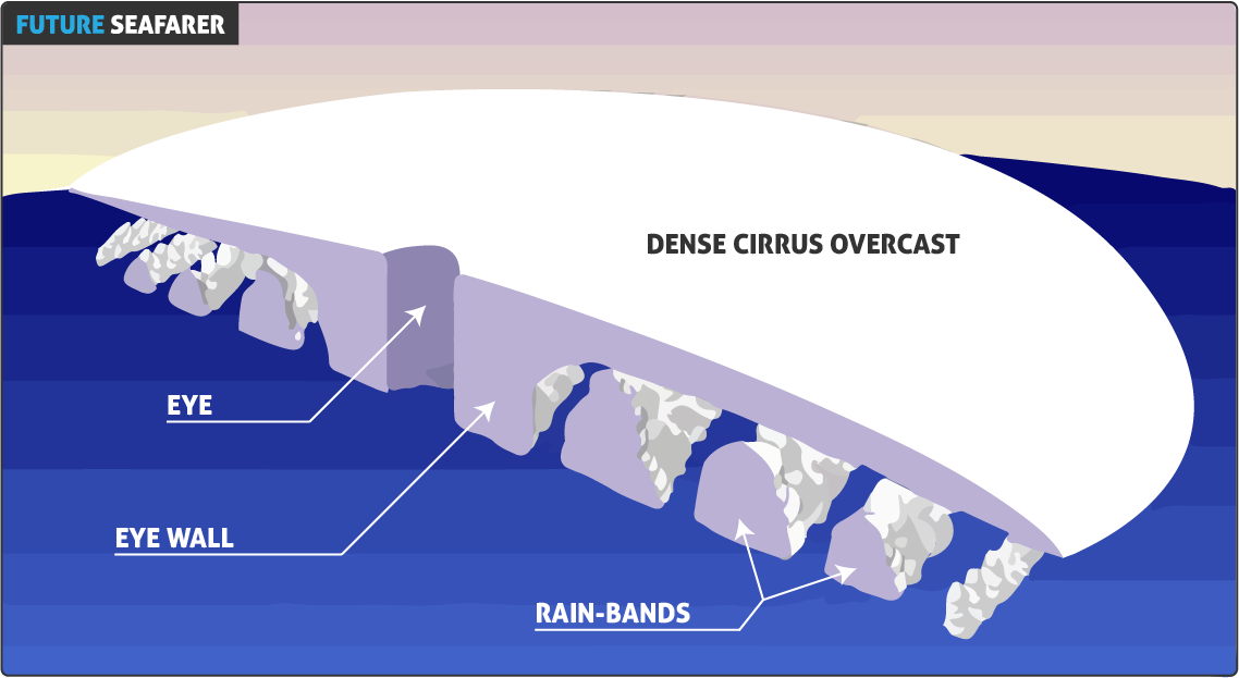
STRUCTURE
EYE
Is The Center Of Tropical Storm.
The Calmest Part Of The Storm.
Generally Clear Area Of Sinking Air.
Winds Usually Do Not Exceed 13 Knots.
The Width Is Between 17 & 34 Nautical Mile.
EYE-WALL
Consists Of A Ring Of Tall Thunderstorms That Produce Heavy Rains.
Usually The Strongest Winds And Blow In A Perfect Circle With A Speed Of 130 Knots And Sometime Goes Upto 150 Knots.
The Width Usually Between 3 & 26 Nautical Mile.
RAIN-BANDS
Curved Bands Of Clouds And Thunderstorms That Trail Away From The Eye Wall In A Spiral Fashion.
These Bands Are Capable Of Producing Heavy Bursts Of Rain And Wind, As Well As Tornadoes.
There Are Sometimes Gaps In Between Spiral Rain Bands Where No Rain Or Wind Is Found.
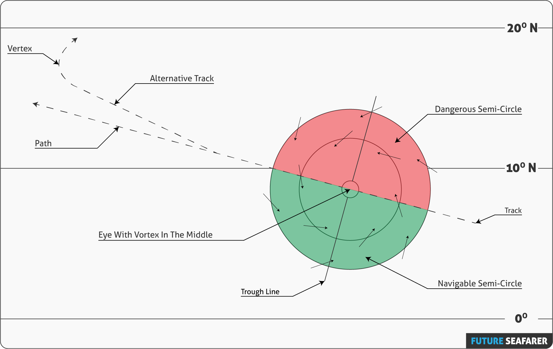
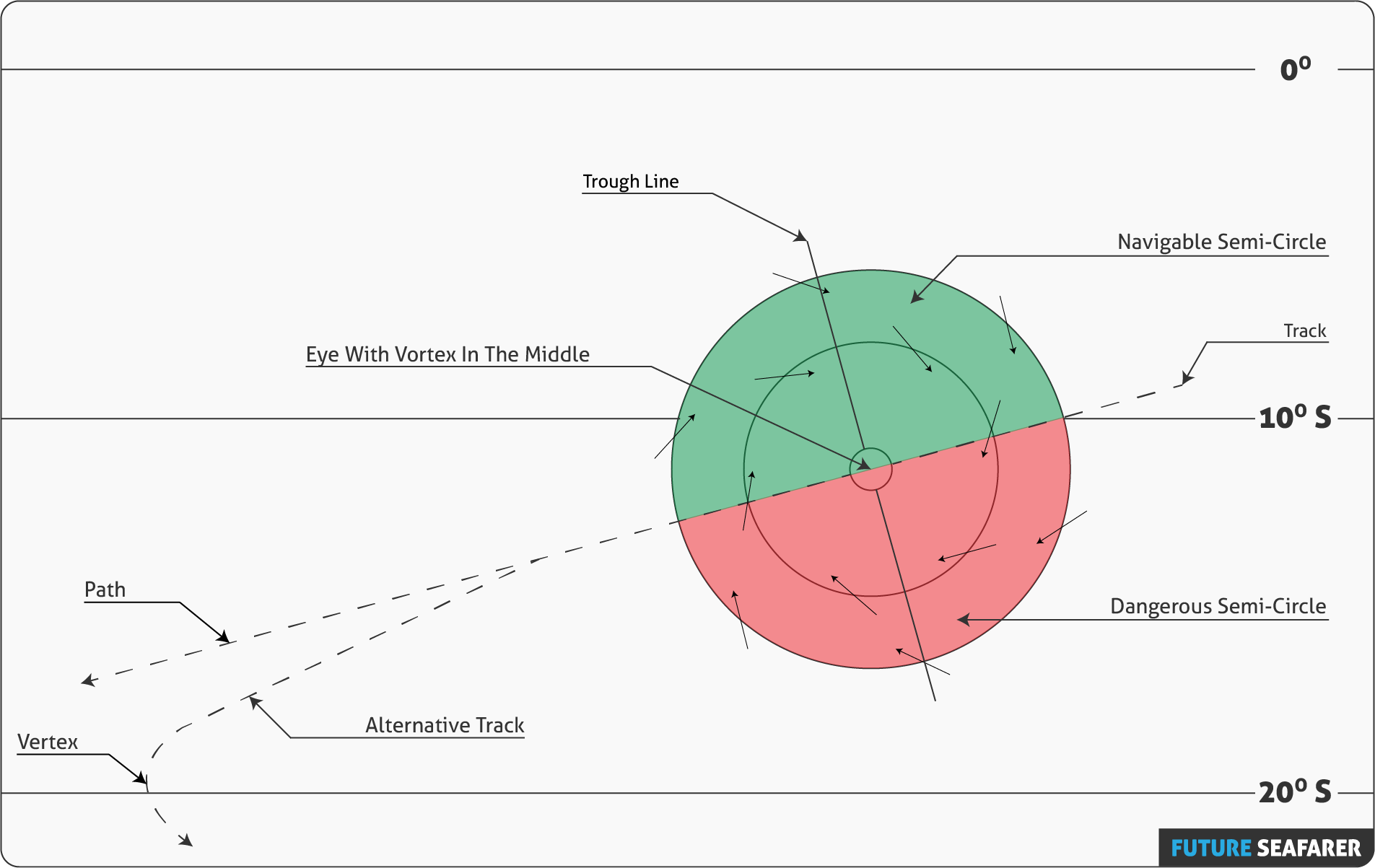
SECTIONS
TRACK: Is The Route Which The TROPICAL REVOLVING STORMS Already Passed.
PATH: Is The Predicted Route, Which The TROPICAL REVOLVING STORMS Might Be Passing At Near Future.
VERTEX: Is The Most Western Point Where The Track Re-Curve Takes Place.
NAVIGABLE SEMICIRCLE: It Is The Side Of A TROPICAL REVOLVING STORMS, Where The Winds Are Weaker And Better For The Navigation Purpose.
DANGEROUS SEMICIRCLE: It Is The Side Of A TROPICAL REVOLVING STORMS, Where The Storm Has The Strongest Winds And Heavy Seas.
TROUGH LINE: Is An Extended Region Of Relatively Low Atmospheric Pressure.